In January 2022, authorities in New Mexico, USA, began a series of prescribed burns. Months later this became the worst fire catastrophe in this state.
Prescribed, or controlled burns, are fires that are carefully planned and designed by experts for forest management. The goal of these fires includes the restoration of natural woodlands and landscape management. Most importantly, prescribed burns are used to reduce the amount of potential fuels present in the woodlands. Reducing woodland fuels leads to a reduced risk of uncontrolled fires appearing due to lightning or human activities.
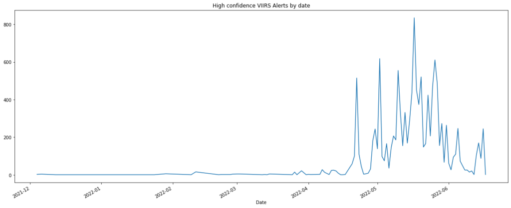
In January, a small set of prescribed fires was started by a team of federal employees in New Mexico, in the south of the United States. Three months later, in April, some of these fires escaped control due to a combination of hot, dry and windy conditions. Part of this story can be seen on the following graph, showing high confidence VIIRS fire alerts in a study area enclosing the national forests affected by the fires from December 2021 to the 20th of June 2022. It can be seen that by the end of April the number of fire alerts skyrocketed, reaching its overall maximum around the middle of May.
One of the most important wildfires occurred in the northern part of New Mexico, in the Santa Fe National Forest. This fire is now known as the Hermits Peak wildfire and it is one of the worst forest fires in the history of New Mexico. By the 8th of May, this fire had burned an estimated area of 680 km². By June 17th, the area went up to 1070 km², which averages to almost 10 km² burning per day. You can find a detailed report about this fire here.


Overall, we estimate that the total amount of surface burned in our study area for Mew Mexico by June 20th is about 2825 km², an area bigger than the city of Los Angeles.
Many of these uncontrolled fires happened close to urban areas, where the population was evacuated. Several buildings were reached by the fire, leading to thousands of people losing their homes and businesses. Currently, the US Government is being held responsible for the disaster and families are demanding remuneration for their losses.
As the last part of our series about our BlazeMap™, below you can explore the dates and extent of the burned areas in our study region for New Mexico from 1st March 2022 to 20th June 2022. The areas are classified according to a pixel-wise based machine learning model.