BlazeMap™
With our artificial intelligence system, we deliver precise wildfire mapping for your study area. Our powerful computers process thousands of satellite image within hours without human intervention. Our software ensures scalability, accuracy and speed:
scalability
We can map areas of any size from national parks to large countries. The largest study area we've mapped so far had one million square kilometers. That's equivalent to the land area of British Columbia.
highly detailed maps
Our maps feature a resolution of 40 meters. That means that unburned islands and fire nests as small as 0.5 hectares are detected. For each fire cluster we determine when the fire started and ended.
timely delivery
We can deliver the BlazeMap™ within a few working days after you place your order. That includes downloading the satellite data, running it through our AI system, and having a wildfire scientist check the result.
The BlazeMap™ system builds on the know-how of our forest & geodata scientists. Our experts ensure that you get the quality, advice and flexibility you need:
guaranteed quality
Our wildfire experts continuously improve our algorithms. Furthermore, we vet every map before we deliver it to you. That way you can count on receiving the best possible quality.
expert advice
Our forest scientists are available to answer any questions you might have before and after delivery. If desired, we can provide extended geospatial analysis to augment the BlazeMap™.
flexibility
We listen closely to your specific needs. Do you need a better resolution, ancillary information or a statistical report? Then let us know. We will tailor our product to your requirements.
Wildfire Mapping Showcase
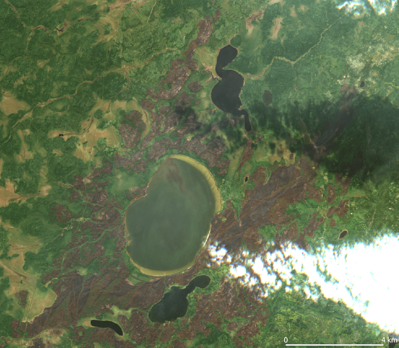
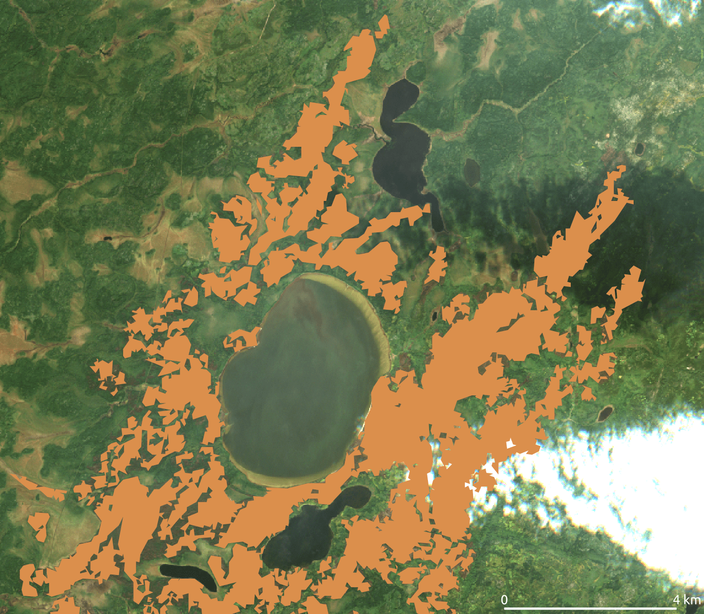
With EDEO BlazeMap™ you'll know exactly where and when wildfires occurred. Use the slider on the left to see for yourself how closely the BlazeMap tracks the burned area visible on the satellite image.
- Fire perimeters are traced with 40-meter resolution.
- Fire nests and unburned islands as small as 0.5 hectares are tracked.
- Burned areas under clouds are reliable detected through time series analysis.
- Our artificial intelligence can detect burned areas in cloud shadows and through smoke.
EDEO Wildfire News & BlazeMap™ samples
BlazeMaps have been used around the world. Check out our news releases for more details.
The Fire Season in Western Australia 2022
Australia is widely known to have an extensive fire season during Summer. However, in recent years it is common that the fire season extends to Autumn or even Winter each year. In fact, a recent study suggests that the burned area during this season has increased...
Record emissions from wildfires in Argentina
According to the Copernicus Atmosphere Monitoring Service, fire activity in the first months of 2022 in South America has been the most intense since the beginning of the study, in 2003. What is the meaning of this? Sadly, the meaning of this is that we can...
Nine First Nations Evacuated due to Wildfires near Lake Winnipeg in 2021
What happened? Over the summer of 2021, over one million hectares of forest burned down east of Lake Winnipeg (Ojibwe: ᐑᓂᐸᑲᒥᐠᓴᑯ˙ᑯᐣ) in Canada. The affected area straddling the Manitoba-Ontario border is mostly inhabited by First Nations. Over 8 000 residents from nine...
Use Cases

wildland fire science

emission quantification

damage assessment

land slides & soil erosion

flood prediction

public information
Pricing
We have a simple pay-per-map model. Let us know your study area and period of interest*, and we'll send you our quote. The price consists of a base price plus 8 cents per square kilometer**:
8400 € + (area × 0.08 €/km²)
* If your period of interest exceeds 12 months, we create a separate map for each fire season.
** Minimal study area is a Sentinel-2 tile (110x110 km²)
Example pricing for mapping one fire season in California:
base price € 8 400.—
424 000 km² × 0.08 €/km² + € 33 920.—
_______________
€ 42320.—
80% early adopter discount − € 33856.—
_______________
You pay: € 8464.—
Early Adopter Discount:
For orders placed until 31 May 2024, we give
80% off the final price
Offer expires in:
Day(s)
:
Hour(s)
:
Minute(s)
:
Second(s)
Get In Touch!
Do you have questions about BlazeMap™? Need a quote?
Give us a call or send us an email. We are looking forward to your inquiry!
Address
EDEO GmbH
Reinwaldstraße 14
93426 Roding
Germany
Phone Number
+49 9461 6388776
E-mail
info@edeo-gmbh.de
